
Glaciers and Glacial Warming, Receding Glaciers
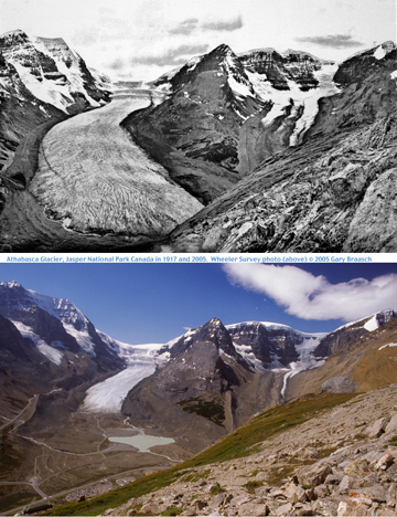
The first photographs made for World View of Global Warming, more than ten years ago, were of glaciers in Antarctica and Peru. This page shows a selection of the locations where we have documented glacier and ice cap retreat -- a small set of images illustrating the overwhelming evidence from hundreds of glaciers and ice caps on every continent that global warming is severely affecting the water and glacial cycles of the planet. This is a profound change that unlike natural cycles like the Little Ice Age of the 16th and 17th centuries is proceeding very rapidly and appears tied to no natural cycles. The best correlation for this change, happening on all but a handful of the 160,000 land glaciers and parts of the great ice caps, is to rising atmospheric temperatures tied to increasing amounts of greenhouse gases. The largest implication of this loss of glaciers is not the change in scenery, but the fact that the seasonal meltwater from glaciers, especially in Asia and South America, is the life support for billions of people. Large cities like Lima get much of their water from glaciers. In other parts of the world, glacier water keeps streams cool and full for salmon and other important wildlife. And as more and more water reaches the ocean, it is increasing sea level at a faster rate --- which threatens every coastal city and shoreline. New scientific projections show at least a three foot (one meter) rise in ocean levels by the end of this century, part of which is also due to the expansion of warming sea water. This will inundate rice fields and estuaries that feed billions, and push into the heart of the worlds largest cities --- and make each storm a threat of more devastating waves and surges. 1919 image of Athbasca Glacier, Jasper National Park, Canada, courtesy National Archives of Canada, from the Wheeler Survey; 2005 image © Gary Braasch
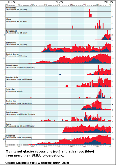
This chart is from http://www.grid.unep.ch/glaciers/ |
Ice Under Fire: Antarctica
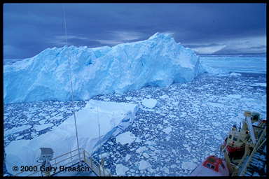 The disintegrating
face of the Müller Ice Shelf, Lallemand Fjord, Antarctic
Peninsula, 67° South, April 2, 1999. This small shelf, fed
by glaciers from the Loubet Coast, has been receding recently after
growing over a 400-year cooling period. Like other receding ice
shelves such as the larger Larsen, it may be a sensitive monitor
of rising regional temperatures. The Larsen Ice Shelf lost a 1200
square mile section early in 2002, prompting some glaciologists
to be concerned that even the giant Ross Ice Shelf could be at risk.
The disintegrating
face of the Müller Ice Shelf, Lallemand Fjord, Antarctic
Peninsula, 67° South, April 2, 1999. This small shelf, fed
by glaciers from the Loubet Coast, has been receding recently after
growing over a 400-year cooling period. Like other receding ice
shelves such as the larger Larsen, it may be a sensitive monitor
of rising regional temperatures. The Larsen Ice Shelf lost a 1200
square mile section early in 2002, prompting some glaciologists
to be concerned that even the giant Ross Ice Shelf could be at risk.
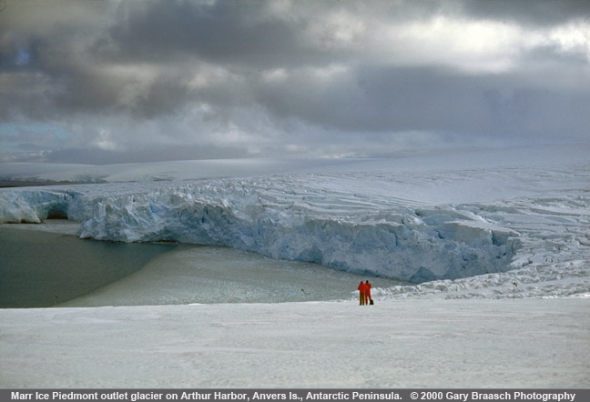
This mile-long ice cliff of Marr Ice Piedmont, Anvers Island, has receded about 500 meters since the mid 1960s. The cliff's previous position was to the left of the line of ice floating in the harbor and extended to the headland at the extreme upper left. The regional temperature has increased 5° C in winter over the past 50 years. This reduces seasonal icepack, disrupts growth of krill and changes conditions on penguin rookeries.
For more on Antarctic ice and climate, please see Ice Under Fire, the Antarctic section.
Ice Under Fire: Arctic
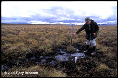 Geophysicist Tom Osterkamp indicates ground level when he installed this temperature probe
pipe near Denali Park, 15 years ago. Alaska permafrost temperature
has increased 0.5° to 1.5° C since 1980, when Osterkamp
began measuring ground temperature at 30 sites. Many of those sites
show thermokarsting like this. Serious effects include forest damage,
sinking roads and buildings, eroding tundra riverbanks, changes
in tundra vegetation, and increased carbon dioxide and methane emissions
from thawed peat
Geophysicist Tom Osterkamp indicates ground level when he installed this temperature probe
pipe near Denali Park, 15 years ago. Alaska permafrost temperature
has increased 0.5° to 1.5° C since 1980, when Osterkamp
began measuring ground temperature at 30 sites. Many of those sites
show thermokarsting like this. Serious effects include forest damage,
sinking roads and buildings, eroding tundra riverbanks, changes
in tundra vegetation, and increased carbon dioxide and methane emissions
from thawed peat
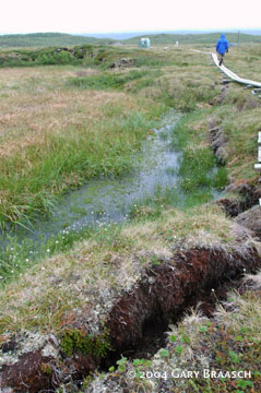
Just how serious a threat thawing tundra can be is being measured in Northern Sweden. Rising atmospheric temperatures are causing the disappearance of permafrost and its replacement with marshland or open water. At Stordalen Mire near Abisko National Park, where careful records and aerial photos were available for comparison, the amount of wetland increased more than 50 % at the expense of higher dry land which had been underlain by permafrost. Study leader Patrick Crill reports this has increased the emission of methane from the mire, a powerful greenhouse gas, by as much as two-thirds over 1970 emissions. A 2004 study by Torben Christensen and others directly measured hydrocarbon emissions from the Mire, and found that almost all the emissions were methane. The scientists express concern that methane emissions seem to increase with temperature and could be a positive feedback creating even more atmospheric warming
Ice Under Fire: Mountain Glaciers
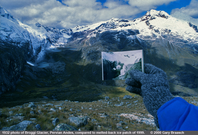
Photographer Gary Braasch holding a 1932 photo of Broggi glacier near Huascaran in the Peruvian Andes, while rephotographing this receding glacier in 1999. Glaciers everywhere in the world (with a very few exceptions) have been shrinking throughout the 20th Century, a prime signal of rapid global warming. Loss of tropical glaciers is particularly rapid. This glacier, previously photographed by the Austrian Hans Kinzl, receded about one kilometer in 67 years.
Here is a series of other receding glaciers in "then and now" views
|
|
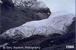 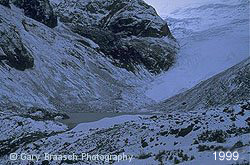
Glacier Ururashraju, at about 15,000 feet in Cordillera Blanca of Peru. Photographed in 1986 by Peruvian glaciologist Alcides Ames, whose studies and direction allowed Gary Braasch to rephotograph it in 1999. Retreat of about 500 M. Ames studies confirms the very rapid deglaciation of the Cordillera Blanca, which is the most ice-covered mountain range in the tropics. |
|
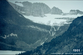 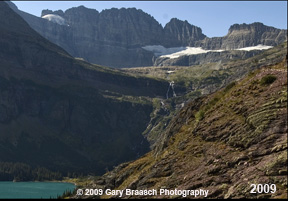
Grinnell glacier, Glacier National Park, USA, has receded out of sight. Photographed by a park photographer in 1911 and by Gary Braasch in 2009. Estimates by US National Park Service scientist Dan Fagre are that all but a few of the 30 glaciers in this Northern Rocky Mountains park will be gone by mid-century. |
|
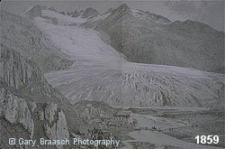 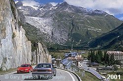
Perhaps the most dramatic glacier withdrawal has been in the Alps, where it has occured in full view of residents, tourists and scientists. This is a 1859 etching of the Rhone glacier in the Kanton of Valais, Switzerland, when the ice filled the valley right to the tiny crossroads of Gletsch. In 2001 the glacier was nearly out of sight, 2.5 km distant and 450 M higher. (Ciceri etching courtesy Stefan Wagner, from Uber die Furka [1999, Limburg a/d/ Lahn, Germany].) |
|
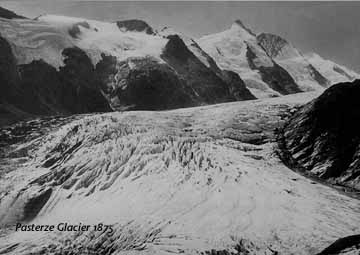
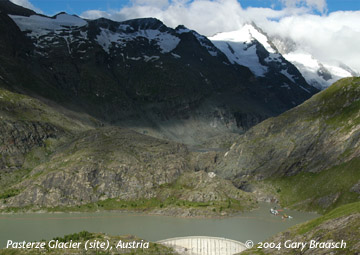
1875 photo courtesy H. Slupetzky/University of Salzburg The Pasterze, Austria's longest glacier, was about 2 kilometers longer in the 19th C. but is now completely out of sight from this overlook on the Grossglockner High Road. The Margaritzen-Strausee, a dammed artificial lake, now is in the place where the glacier terminus was in 1875. Measurements of the Pasterze began in 1889 and it has been pulling back the entire time, in approximate step with regional temperatures that have been increasing. The glacier is now about eight Km long and loses about 15 meters per year. However in 2003 the Pasterze decreased 30 meters in length and 6.5 meters in thickness. [1875 image, photographer unknown, is courtesy H. Slupetzky, from the University of Salzburg archives. Gary Braasch photo made Aug 14, 2004] |
|
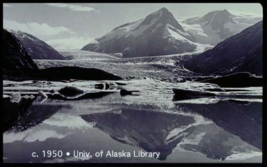
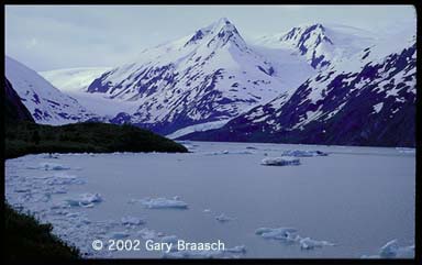
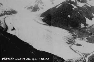
Alaska's glaciers, 34,000 square miles of ice, an area about the size of Maine, are receding at twice the rate previously thought and beginning to contribute significantly to sea level rise, accoridng to studies in Science journal. These two images show Portage Glacier, near Anchorage, Alaska, in about 1950 and in July 2001. The ice has pulled back nearly out of sight. |
|
 |
 |
Portage Glacier 1950 (historic photo from the Lulu Fairbanks Collection, University of Alaska Library, used by permission.) |
Portage Glacier 2002 |
 |
 |
Portage Glacier 1914 |
Portage Glacier 2004 |
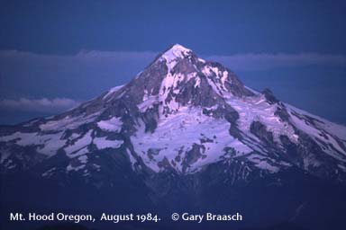
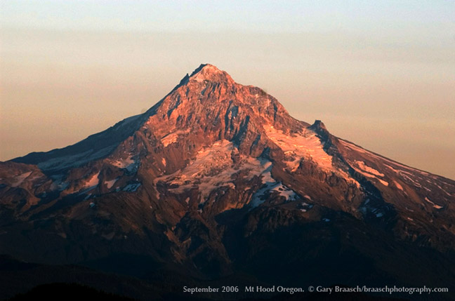
Glaciers in the Northwest United States have also been shrinking, under pressure from rising temperatures, longer summer seasons, and a rising snowline. Studies by the Climate Impacts Group at University of Washington show regional temperature has been 1.5° F warmer in the 20th century, with decreasing mountain snowpack, and earlier spring runoff. The occasional year of extraordinary snowfall does not make up for the record of decreasing snowpack all across the American West. These photos of Mt. Hood Oregon comparing late season snow and ice only 18 and 22 years apart indicate the problem: There is much less late summer ice from which the region gets water for irrigation, drinking, and fish habitat. Mt Hood has lost more than a third of its ice since first measurements in the early 20th c., according to Glaciologist Andrew Fountain of Portland State University.
|
|
 |
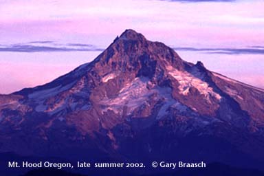 |
Mt. Hood Oregon August 1984 |
Mt. Hood Oregon late summer 2002 |
 |
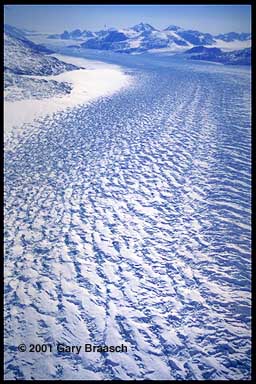 |
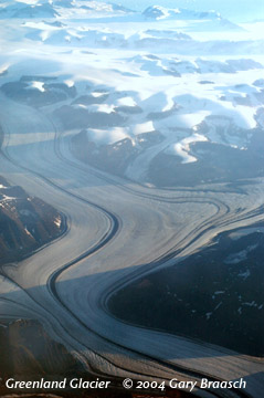
Greenland's huge icecap, second only to Antarctica, is also showing signs of change, and NOAA's state of the Arctic report for 2010 says the indicators include record setting high temperatures, rapid ice melt and water flow, and glacier area losses. Researchers reporting in scientific journals documented that records were set in 2010 for length of Greenland's annual melting season, the amount of water runoff from the ice surface, loss of surface ice and the number of days when ice was bare rather than blanketed by snow. Summer snowfall was below average, also, and surface temperatures were higher than average, according to the scientists. Outflow glaciers like this one on the central east coast, as measured by NASA airborne radar and laser, are thinning and flowing more rapidly. Two deep ice cores from the crest of Greenland's ice sheet provide a detailed Northern Hemisphere climate record extending beyond the last ice age.
|
|
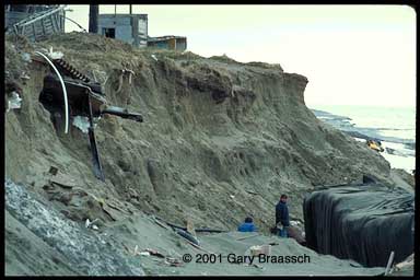
Around the globe, sea level is more than 6 inches higher than it was 100 years ago, due primarily to warmer sea water and runoff from melting glaciers. The rate of rise is now 12 inches per century and increasing. The IPCC projected in its 2007 report a sea level up to 2 feet higher by 2100. However, leading glaciologists have long maintained that accepted estimates of sea level rise were underestimated, due to the rapid retreat of mountain glaciers and the unpredictable change to ice caps in Greenland and West Antarctica. Studies released in 2008 and 2009 using various satellite sensors of the sea surface plus estimates of continuing ice cap and glacier melt indicate sea level will be three feet or more higher by the end of the century. This is a devastating forecast for low lying areas from Pacific islands, to Bangladesh, to Florida's low-lying coast and Everglades (see next), and parts of all major coastal cities. In Alaska, the native village of Shishmaref, in the photo to the right, is suffering severe effects of sea level rise already. |
|
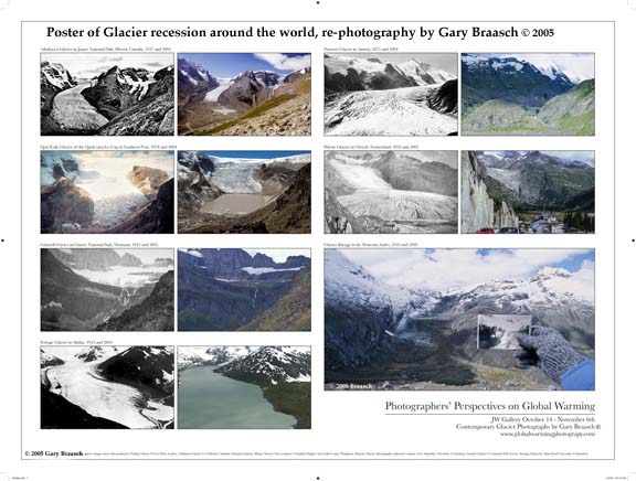
Photographers' Perspectives on Global Warming |
|
"Sez who?": References
Each of the foregoing photos reports on documented science, peer-reviewed published studies and scientific literature surveys. Those references are listed later in this Web site, along with climate change data, World View of Global Warming project advisors, and links to some sources of climate information.
Photographs from the World View of Global Warming are available for license to publications needing science photography, environmental groups and agencies, and other uses. Stock photography and assignments available.
Please contact requestinformation@worldviewofglobalwarming.org or Gary Braasch Photography (503) 860-1228.
Use of photographs in any manner, in part or whole, without permission is prohibited by US copyright law. These photographs are registered with the US Copyright Office and are not in the Public Domain.
![]()