


Water and Climate in the Himalayas
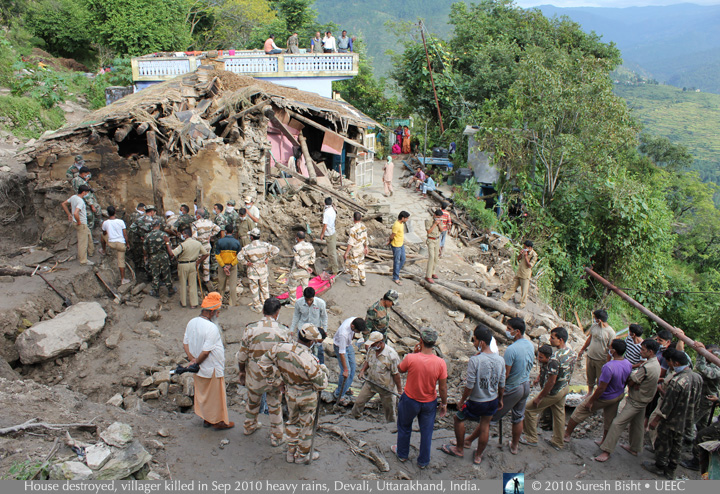
The mountainous and heavily populated region of the Himalayan foothills has long been the scene of landslides and river flooding during the predictable rains of the monsoon. Historically, most slides are set in motion in June, July and August and about ninety percent of the fatalities occur in those months. In recent years, however, according to studies and reports, more residents are the victims of unexpected storms, more frequently outside the expected monsoon months. Intense and prolonged rain, and storms at unusual times of the year, are among the expected effects of a warming climate. Like the village of Devali in Uttarakhand India in this photograph, where homes and lives were swept away in September 2010, the Indian Himalaya and Nepal have been suffering from unusual or repeated landslides.
A recent journey with support from the Karuna Foundation US, we saw the damage and long-term disruption caused by landslides The photos and research presented here were made through the gracious cooperation of the Uttarakhand Environmental Education Center (UEEC), and World Wildlife Fund - Nepal (WWF). Additional information is from International Centre for Integrated Mountain Development (ICIMOD) reports, other NGOs and press reports.
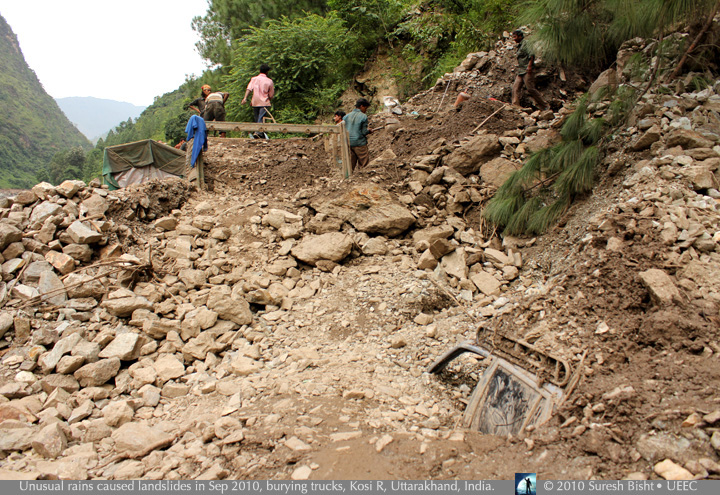
What was called the heaviest monsoon in 100 years flooded the area around Almora in September 2010, killing at least 72 people, washing away more than 25 homes, and cutting roads and utilities. This photo of a road along the Kosi River was made by a UEEC staff member during a trip to see how the educational NGO could help the people in villages they serve. Only a month before, severe downpours had stuck the same area, and a hillside collapsed according to police reports, creating “a huge amount of rocky slush that hit and crashed the wall of one of the classrooms” of a school near Kopkot. The roof collapsed, killing 19 students. Even a year and a half later when we visited this area, many buildings and roads had not been repaired due to lack of funds and construction crews.
The storms of August and September 2010 were particularly severe above Kopkot and the valleys leading down to the Revati River and other tributaries of the Saryu river. The UEEC’s Anuradha Pande emailed a friend that the people there “did not realize that a cloudburst could be so dangerous. There are landslides everywhere...roads, agricultural fields have been washed away. there is no electricity, no phones, no ration in the shops. Debris of landslides has gone inside the houses and the rooms are full of water and mud....one can not step in...so, the people are spending nights in the open.”
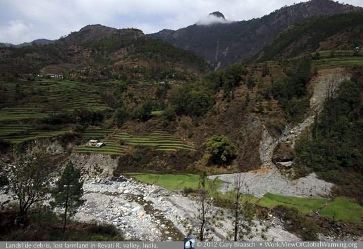
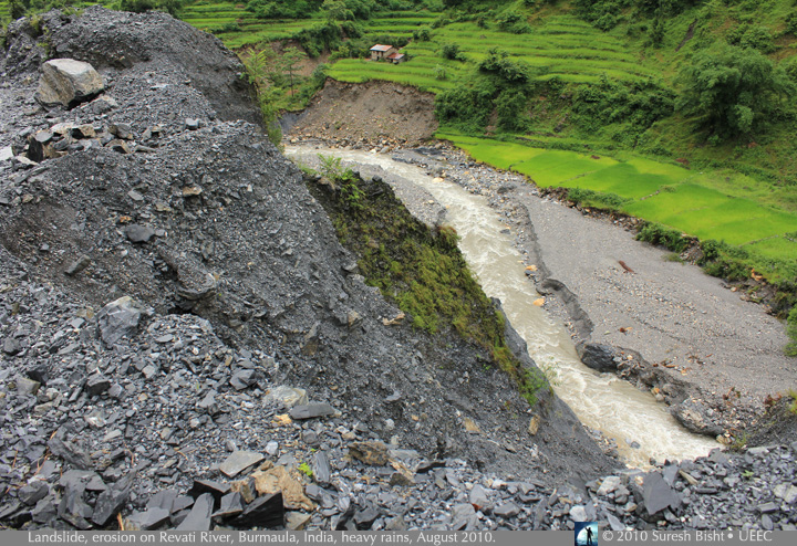
This is the same area on the Revati River in Bageshwar District of Uttarakhand as in the previous photo, a year and a half later in March 2012. A second slide happened later in 2010 and the river ate away further along the opposite bank, endangering the house on the terraces. More than 50 major landslides were recorded in August and September 2010 by a geotechnical study team, whose report cited steep slopes, high relief, overburden of erosion debris, as well as human alterations of the slopes as the main factors in the severe damage. But the report ends by saying, “The most important causative factor for the triggering and development of landslide(s) is the continuous heavy rainfall.”
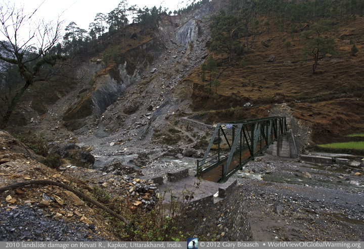
Farther down the Revati River toward its confluence with the Sarju River, damage from the landslides 18 months before still appears fresh, and trails have been made to get pedestrians up onto the bridge.
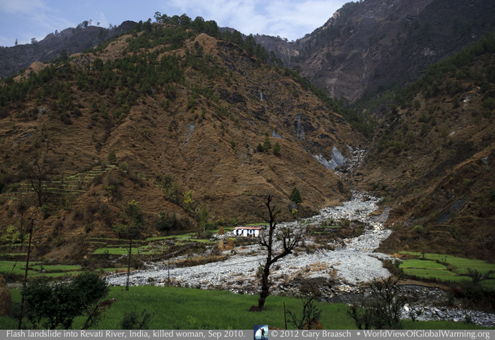
A flash landslide down this side valley of the Revati River in Burmaula, India, in September 2010 killed the woman in the house. People have lived in this valley for several hundred years, building farm terraces and buildings out into old side valley bottoms and across steeper slopes to increase the yield and accommodate the rising population. But apparently the valley was not always free of the landslide threat: after the intense rains and debris cascades of 2010, some residents said their grandparents had talked of a previous period of landslides about 100 years ago.
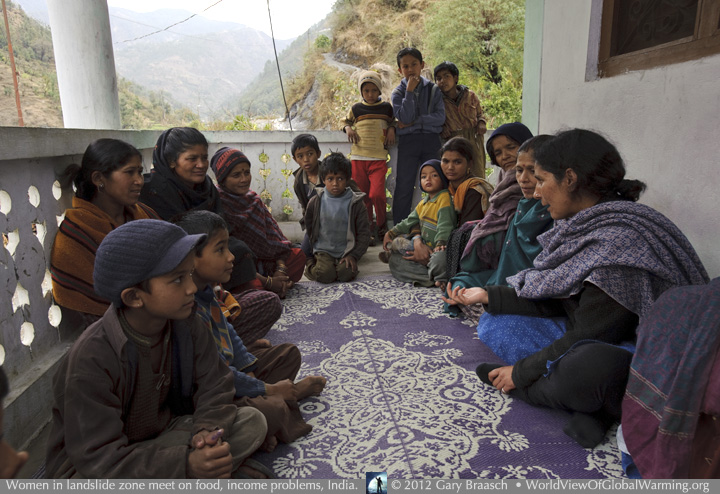
With a view upriver and along the very steep valley sides traversed by road and trail, Anuradha Pande, a co-founder of the Uttarakhand Environmental Education Center (UEEC), speaks at a meeting of Burmaula village women with some of their children. Women are strongly affected by changes in rainfall, slide damage, weather shifts that reduce crop yields and long-term drought. The UEEC has encouraged meetings like this, which were originally focused on education and the care of children but in many villages have gained power in the community on domestic issues, water distribution, forest protection and response to emergencies.
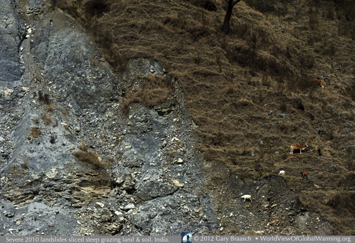
Among the new dangers to the farming community of Burmaula, Uttarakhand, India, is the raw landslide scar across the river, where the intense rainfall of September 2010 peeled off a section of steep pasture. Many river crossings, pathways, terraces and pastures were damaged by the event, making it even harder for this village to raise their subsistence crops of wheat, vegetables, potatoes and citrus fruit.
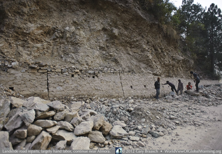
The main road from Almora to Kathgodam, India -- the route out for commerce, to hospitals, and toward the nearest rail station -- was torn up for a kilometer by raging river waters during the September 2010 storm. Even now, more than a year and a half later, it is still under repair, almost entirely by hand labor.
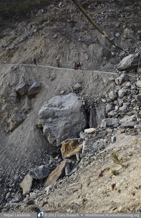
Residents of Jibjibe and Kalakistan, Rasuwa District, Nepal cross the steep and still active landslide between the towns on a “temporary” road cut into the scar after the slide ten years ago. A leaky pipe suspended above carries drinking water over the chasm. Jibjibe is actually bracketed by landslides, because of another slide in 2003 that affected portions of Dhaibung and Bhorle, and killed 7 people. Jibjibe’s isolation between is forcing the upgrade of the medical facility because people sometimes can no longer travel quickly to other hospitals. The extremely steep landscape and lack of funds to more permanently bridge active landslide valleys is one reason why increasingly heavy rains and threat of more landslides and floods is a concern across the Himalaya.
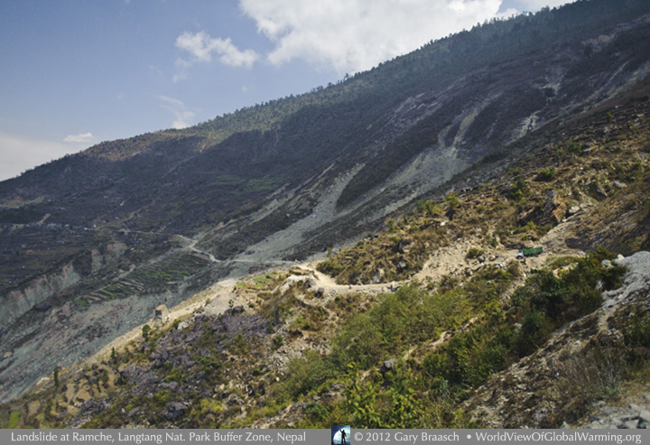
At the same time as the Jibjibe landslides of August 2003, an even larger landslide tore down a broad slope, ripping between parts of the town of Ramche, farther north near the border of Langtang National Park. A Nepali army camp was dead on in the path of the debris flow, and 20 personnel were killed. Ramche, a village of about 2500, remains divided and suffering more slides, and the main road from Kathmandu into Langtang above the Trisuli River toward China has never been resurfaced and is closed by monsoon rains.
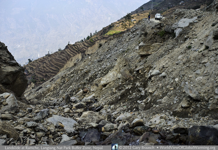
WWF personnel in Nepal call this area “the most vulnerable district in Nepal” from landslides -- an unfortunate living laboratory for the accepted prediction that rainstorms over the Himalaya will intensify due to global warming. A digest of studies published over recent years said: “what is more important than changes in average precipitation are the changes in extreme precipitation events. It is these events that trigger landslides and cause rivers to flood, and it is very likely therefore that there will be an increase in these events due to the increase in intensity and frequency of extreme rainfall.” Ramche is also a regional reaction in changing water use and farming, to try to reduce the effect that cultivation on 40-60 percent slopes has had in loosening and weathering the loose rocks, as reported by a study of the landslide. See the Water portfolio here for more about innovative farming in Ramche.
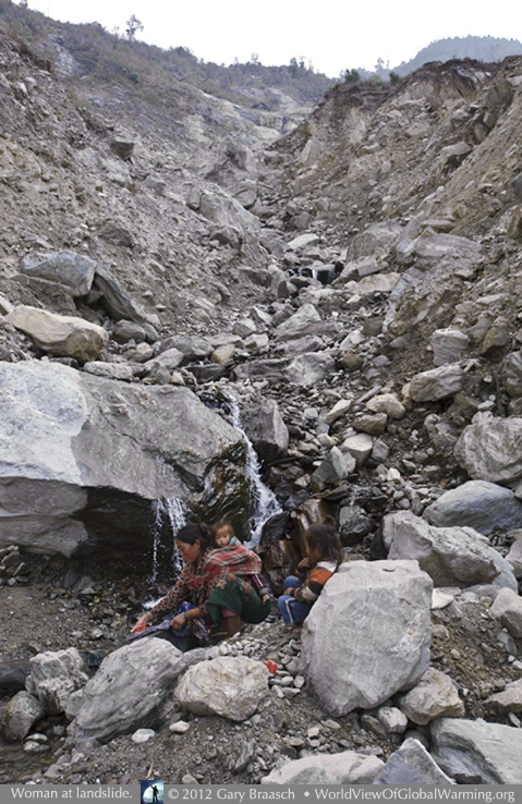
A woman from one of the parts of Ramche most isolated by the landslide washes clothes with her young kids amid the debris of the slide. Many village water sources were cut or buried by the slides and since parts of the slide continue to move downslope toward the Trisuli River, creating permanent water lines and faucets is difficult.
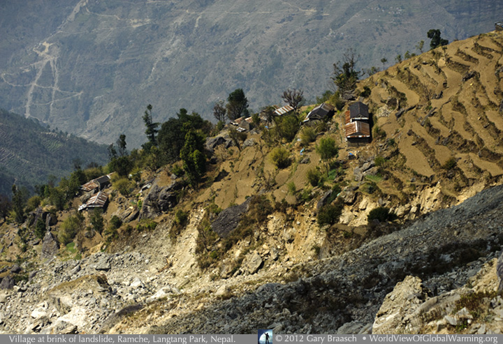
Parts of Ramche village are in a very precarious situation, since the slide continues to eat away at the steep terraced hillsides during heavy rains. WWF workers in the area said the farmers downslope are unable to leave their land because it is their main possession and they have nowhere else to go. They could be among the unfortunate next statistics of a growing toll of landslides: According to a UN study, for example, between June and August 2011 159 people were killed and more than 60 were still missing in landslides in every region of Nepal. This year, 2012, saw a flash flood along the Seti River near Pokara which resulted in the death or disappearance of at least 72 people, and a great loss of property. This disaster was apparently triggered not by rainfall but by a huge rock and/or icefall above the source of the river high on Annapurna II, according to NASA and ICIMOD, but is not well understood at this point.
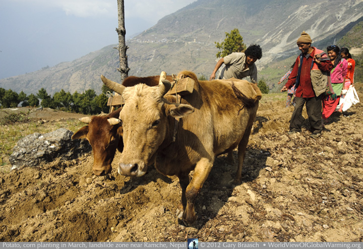
Meantime, farmers all around the landslides of Rasuwa District in Nepal continue as they must to plant and harvest, but increasingly with more knowledge of how to protect the land and deal with climate changes. With the great Ramche slide as backdrop, farmers of the Laharapauwa community in the Buffer Zone of Langtang National Park plant organic potatoes and corn using age-old plowing and locally grown seed and seed-potatoes. Visible behind them also is the Syaubari Community Forest, locally planted and managed to hold the soil, produce fodder for animals, wood for fuel and wintergreen in the understory which is harvested for commercial oil. The wintergreen distillery is underwritten by WWF and loans from private and community sources.
Thanks to all the people who allowed us to photograph and speak with them, and to our guides, interpreters and drivers. Thanks again to the Karuna Foundation - US, the Uttarakhand Environmental Education Center (UEEC), World Wildlife Fund - Nepal (WWF), and local leaders and community members. Please see other portfolios about water and climate change, changes to cooking stoves, and how farmers are adapting to changing climate conditions in the Himalayas.
![]()
Please see other Himalaya stories in the Climate Changes menu above.
OR
Water | Landslide | Cookstoves | Ganges Glaciers | Bhutan
.
COPYRIGHT NOTICE:
Photography and text Copyright © 2005 - 2017 (and before) Gary Braasch All rights reserved. Use of photographs in any manner without permission is prohibited by US copyright law. Photography is available for license to publications and other uses. Please contact requestinformation@worldviewofglobalwarming.org. View more of Gary Braasch's photography here.