

Bangladesh Report
For more photographs, please click here.
Where India meets South East Asia, the history and flow of two of the world's greatest religious cultures mingle in the waters of two of its largest rivers. This is a landscape beyond mere superlatives. The waters created in the Himalayas flow out to east and west as the Ganges and Brahmaputra Rivers. The rivers meet form the Meghna, which is second only to the Amazon, and then course south in hundreds of distributaries to form the largest delta on the planet.
This is the landscape of Bangladesh. The 140 million people share culture with Bengali Indians, Muslims and Buddhists, and to a lesser extent the hill people of Myanmar. Ninety percent of the land is flood plain, and "the country has the world's highest density of rivers per unit of area," according to a book edited by Philip Gain, "so it is called 'The gift of the rivers.'"
This great delta is in constant change. Over time river channels writhe like Medusa's hairdo, forming and eating away islands and sandbars depending on the amount of run off, the rainfall of monsoon and cyclones, and the Bay of Bengal tides. Not quite like the Odyssean story, the Bangladeshi people must look this Medusa in the face. Their fate is not being turned to stone but just the opposite -- seeing their lives washed away. The great cyclones (Southern Hemisphere hurricanes) of 1970 and 1991 taught many lessons to the government and people. There is more tree planting, and better warning and evacuation systems for big storms. The Philip Gain book, however, says forest cover has declined from 18 percent in 1927 to 6 percent in 2000, including plantations.
The people are very resilient and used to the vagaries of river and weather. Still the population living along rivers on land less than a meter above high tide makes the issue crucial. Retired national meteorologist M.H. Khan Chowdhury, citing the latest reports available, said "On an average, river erosion takes away about [19,000 acres] of land every year, About one million people are directly or indirectly affected by river-bank erosion every year in Bangladesh." Dr. Chowdhury is part of group of retired Bangladesh government meteorologists and geologists, who believes "people are not very much aware of the effect on them of sea level rise" and a warming climate. These effects, although not yet extensively field studied in Bangladesh, include heavier river flows from melting Himalayan glaciers, more rapid shifts in river channels, stronger high water changes during storms, more intense cyclones and rainstorms, and the fact that all of these are coming on top of the inexorable rise in the ocean itself. Tidal influence up the rivers extents to Dhaka, so even when river flow is normal the level of water follows the sea.
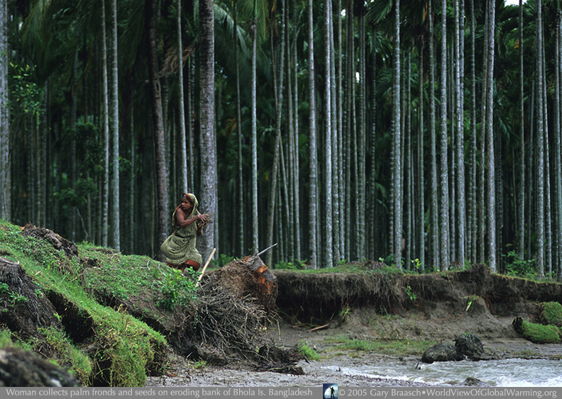
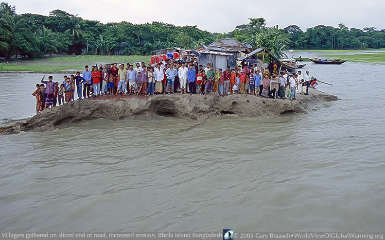
This was impressed on me in a boat journey in June 2005, south from Dhaka. For mile after mile the level of rice fields and buildings along the rivers was no more than a meter above high tide. Much shoreline was lower and filled with water during each high tide. Residents of two villages being eroded away told of faster riverbank loss and of being unable to predict the rivers in time to move houses and rescue families. In the tiny village of Char Kalmi on the west shore of Bhola Island, agitated townspeople pointed out into the river where in April 2005 the mosque was destroyed unexpectedly. This is happening not at the height of monsoon when flooding is common, but at the end of the dry season. I learned that in other villages boat landings are in a constant state of being undermined and even turned into islands during high tides. In the main town of Bhola itself the weather office had to be moved from encroaching waters. Some villages have migrated more than 7 km since the 1980s, leapfrogging houses back away from the edge.
World Bank reported in 2001 sea level rising about 3 mm year in the Bay of Bengal. It warned of loss of Bengal tigers in the Sundarbans, worlds largest mangrove forest, and threats to hundreds of bird species. 15 to 20 percent of Bangladesh is within one meter of sea level. This means predicted sea level rise, at a rate that is increasing, will not only affect millions of people -- estimates are 13 to 30 million -- but will also flood out much rice production. The World Bank warned of a decline of rice crop up to 30 percent with predicted sea level rise. This is not a one-time event that sometime in the future will affect so many. It is a constant process of ever higher tides which affects more and more people even in time of lower river flow and good weather.
References include:
Gain, Philip, ed. Bangladesh Environment: Facing the 21st Century (Soc
for Env and Human Development, Dhaka, 2002.
Notes from meeting with National Oceanographic and Maritime Institute
members in Dhaka, June 23, 2005, and an email follow-up from M.H. Khan
Chowdhury
Interviews with residents of Bhola Island, 24-26 June 2005.
World Bank and UN Environmental Programme reports, and report on Climate.org
"Bangladesh Is Used to Coping, But Rising Seas Pose New Dangers"
![]()
COPYRIGHT NOTICE:
Photography and text Copyright © 2005 - 2017 (and before) Gary Braasch All rights reserved. Use of photographs in any manner without permission is prohibited by US copyright law. Photography is available for license to publications and other uses. Please contact requestinformation@worldviewofglobalwarming.org. View more of Gary Braasch's photography here.