
Source of the Ganges
Portfolios: Water | Landslide | Cookstoves| Source of the Ganges
Journey to the source of the Ganges -- where science and faith meet in concern over the shrinking glaciers of the Himalaya.
Gary Braasch trekked from Gangotri village to the glacier which gave the town its name, a journey which each year is a few meters longer as climate change takes its toll on the Himalaya. The Gangotri Glacier is the source of the Bhagirathi River, a mountain stream which joins with another river below to become the Ganges. The river, the water, the valley and the place where the water flows right out of the glacier are sacred to Hindus and central to the stories of the gods and creation of the river. More photographs from the Himalaya coming soon.
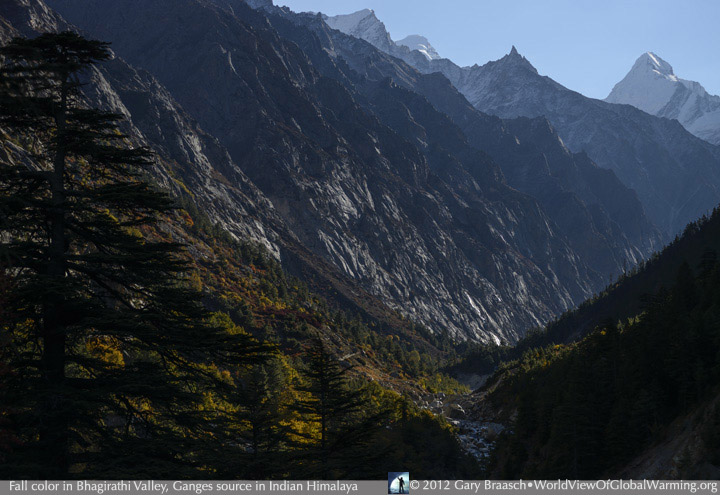
Upper valley of the Bhagirathi River, the main source of the Ganges River, flowing from glaciers of the Gharwhal Himalaya, India. The trek from Gangotri Village in Uttarakhand State to the front of the receeding glacier is now more than 18 km. The trail may be seen in the lower center of this view. In October, fall color is intense from poplar, birch, sumak and other trees. The valley, 6000+ meter peaks and glacier above are protected in Gangotri National Park.
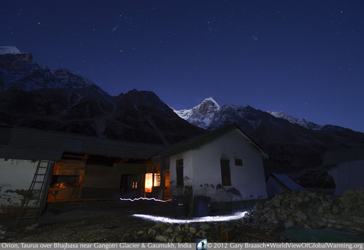
Early dawn at Bhujbasa, India, a camp with a rough lodge and several ashrams, where trekkers and pilgrims rest before walking the final 4+ km to Gaumukh -- the sacred source of the Ganges River. "Gaumukh" means "cows mouth," from the appearance of a cave or hole in the glacier out of which flows the Bhagirathi river which becomes the Ganges. Under the glow of Orion and Taurus constellations and first light on one of the 6500 m Manda Peaks, early risers pass outside the lodge with flashlights.
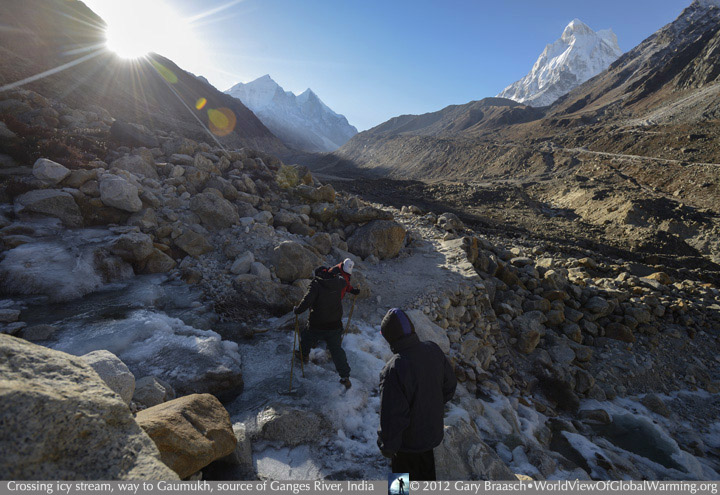
With temperatures in late October well below freezing, crossing side streams is a challenge to a group of trekkers making their way from Bhujbasa camp to Gaumukh. Several km ahead the Bhagirathi Peaks which are over 6800 meters in height, show the location of the glacier. The valley of the Bhagirathi is a geologic book, clearly showing the history Gangotri Glacier by various maraines and terrace levels along the slopes. the highest terraces date from when the glacier filled the whole valley more than 8000 years ago.
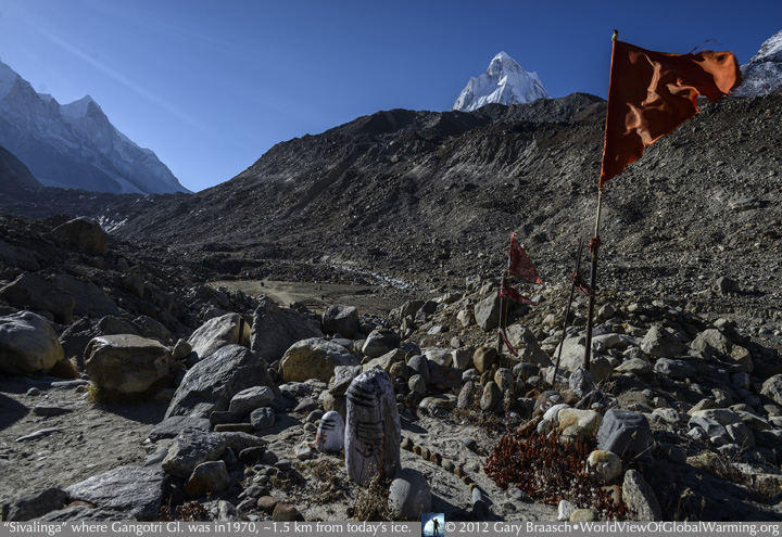
At about 1500 m from the current terminus of the Gangotri Glacier (see the grey areas of ice below the peaks at upper left), a sivalingam, circle of stones and flags mark a shrine where the glacier was in the late 1960s to early 1970s. Holy men, sadhus, and devout Hindu travelers have been coming here for centuries, and the route is well marked with shrines.
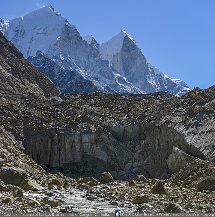
Gaumukh, the sacred glacier source of the Ganges River, where the Bhagirathi River appears right out of the terminus of the Gangotri Glacier. Behind, the up to 6800 meter Bhagnirathi Peaks guard the valley. The glacier terminus is now at 30 degrees 55 minutes 34 seconds North and 79 degrees 4 minutes 48 seconds East -- and retreating approximately 18 meters a year. This is a slower rate than during the late 20th C, probably due to the heavy debris cover on the ice. Despite this, the glacier is rapidly thinning. Glaciologists and meteorologists continue to study to assess the state of climate change in the Himalaya.
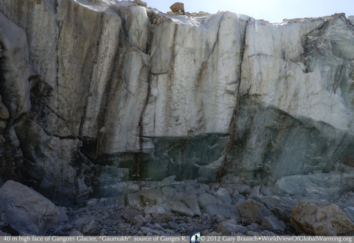
The massive and fissured stone-like 40 m front of the Gangotri glacier at this time does not have a mouth or cave. Rather the lower section is solid greenish-blue ice with marble-like cracks. The river appears to well up a few meters out from the ice. Few people venture this close, and those who want to bathe or collect sacred water find it easier to do so a bit downstream.
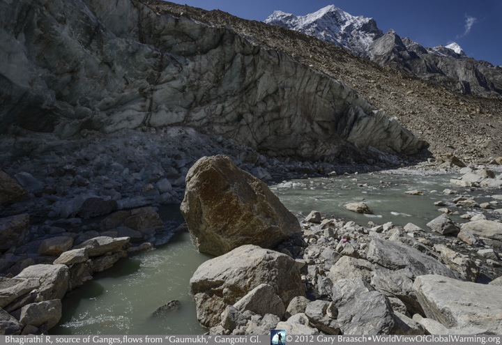
View of the curving and melting side of the Gangotri glacier, with some of the thousands of enormous boulders which the moving ice has deposited in the stream bed. The Bhagnirathi River seems to well up out the earth a few meters out from the face of the glacier -- rather than flow out from an ice cave which has been the case for much of the glacier's recorded history. The water here is grey-green and apparently pure, but only a few kilometers below the human presence along the stream begins the process of the pollution which plagues the Ganges.
![]()
COPYRIGHT NOTICE:
Photography and text Copyright © 2005 - 2017 (and before) Gary Braasch All rights reserved. Use of photographs in any manner without permission is prohibited by US copyright law. Photography is available for license to publications and other uses. Please contact requestinformation@worldviewofglobalwarming.org. View more of Gary Braasch's photography here.